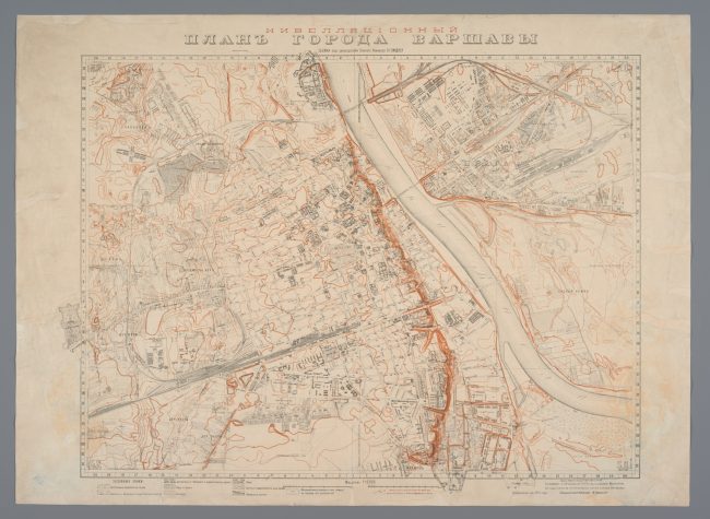
Levelling plan of the city of Warsaw on a scale of 1 : 10,000, drawn up under the supervision of William Heerlein Lindley
The first edition of the presented Lindley’s isarithm plan was released in 1900. The plan from 1912 came as a result of Lindley’s cartographic work related to the construction of Warsaw’s waterworks and sewerage system. The construction was pursued by virtue of an agreement concluded in 1881 between the Warsaw Magistrate and William Lindley (1808–1900) on the basis of his design from 1879. The project bore testimony to the dynamic economic development of Warsaw which at that time, under the Russian Partition, was merely a governorate city. It also confirmed the strategic significance of Warsaw as a garrison town, because waterworks and sewerage system were built here earlier than in the capital of the Russian Empire – Saint Petersburg.
Insofar as the engineering undertaking required the creation of detailed city plans on large scales, mainly 1 : 200, 1 : 250, 1 : 500 and 1 : 1,000 (they were drawn up for Warsaw and the surrounding areas between 1883 and 1915), the cartographic works pursued under the supervision of the Lindleys‘, formally under William Heerlein Lindley (1853–1917), William’s son, are summarised by: multi-sheet plan on a scale of 1 : 2,500 (manuscript and lithographic print), plan on a scale of 1 : 10,000, presented here, as well as highly generalised plan on a scale of 1 : 25,000. Those three final plans lay at the foundation of the municipal cartography of Warsaw in the interwar period.
The contents of the plan from 1912 comprise the street network with names, suburban roads, outlines of landmark buildings, selected local names as well as names of facilities, green areas and surface waters. All inscriptions were written in Russian, as it was the official language of the Warsaw Governorate, one of the ten governorates established following the abolition of the autonomy of the Kingdom of Poland within the Russian Empire in 1867 after the fall of the January Uprising (1863–1864) against the Empire.
The land form (hence the name: levelling plan, i.e. height plan) was represented with contour lines at an interval of one metre; measurement points were marked as well. The plan was drawn up at the Measurement Office by the Waterworks and Sewerage
System Exploitation Department of the Magistrate of the City of Warsaw, which was in charge of charting the city, and was followed after World War II by the Measurement Department of the Presidium of the National Council of the Capital City of Warsaw, Warsaw Surveying Company, as well as the Office of Surveying and Cadastre of the Capital City of Warsaw.
The levelling plan from 1912 is characterised by an unprecedented precision of surveying and imaging of the city. It was the first plan to represent a topographical relief by means of contour lines on a general geographic map of Warsaw. The Lindleys’ plan marked the beginning of a new era in Warsaw cartography: modern, geometrically correct, and entirely based on measurements.
Levelling plan of the city of Warsaw on a scale of 1 : 10,000, drawn up under the supervision of William Heerlein Lindley
WILLIAM HEERLEIN LINDLEY,
DRAFTED AND PRINTED BY THE MAGISTRATE OF THE
CAPITAL CITY OF WARSAW,
HEAD OF THE SURVEYING OFFICE MARCELI JEŻOWSKI
WARSAW; 1912
MULTI-COLOURED LITHOGRAPH
MHW 8237/PL
106 × 77 CM
Image licensed under: ![]()
