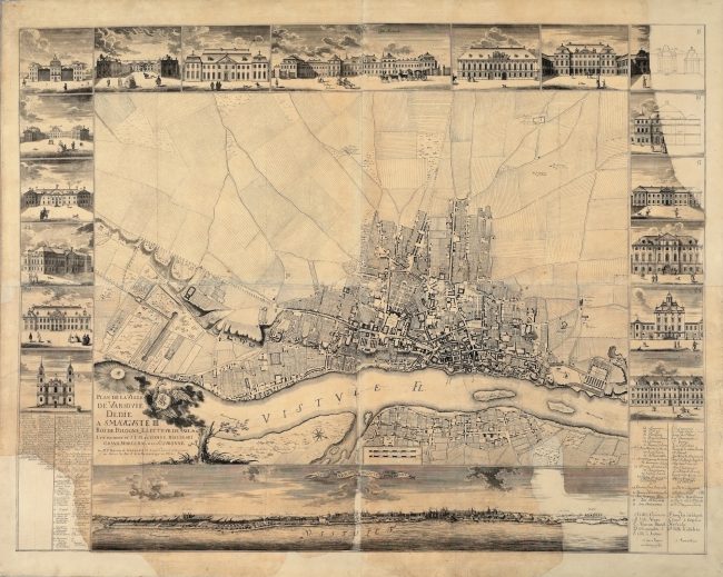
The so-called Tirregaille’s small plan on a scale of c. 1 : 6,750
In May 1761, Pierre Ricaud de Tirregaille (1725–1772), French engineer, geometrician and architect working in Poland in the years 1752–1763, completed a survey in Warsaw which had been pursued since 1758. The measurements were commissioned by Franciszek Bieliński (1683–1766), Grand Marshal of the Crown, who headed the works of the Street Commission established in 1685 and reactivated between 1742 and 1766 in order to arrange and pave the city streets. The measurements were to serve the goal of drawing up a plan of Warsaw. It was created in two versions. The hand-drawn edition on a scale of c. 1 : 1,100 filled twelve sheets of total dimensions of more than seven metres at the base and 3.5 metres in height. It remained the largest plan of Warsaw nearly until the end of the 19th century. The manuscript no longer exists; it burnt down alongside the holdings of the Municipal Archive in November 1944, after the Warsaw Uprising, which was an armed insurrection against the German army that occupied Warsaw during World War II. Presented here is the second version – a copperplate engraving – reduced to a scale of c. 1 : 6,750 and transferred onto four copperplates by the engraver Teofil Jakub Marstalski (1746-1786).
Drawn up in French and Polish and dedicated to King Augustus III of the House of Wettin (Augustus III of Saxony, 1696–1763, King of Poland 1733–1763), the plan provides a detailed image of the city, which comprises representations of the network of named streets, housing and green areas. The largest geomorphological form, the Warsaw Escarpment, was illustrated by means of an expressive plastic hachuring. In turn, the suburban areas were presented according to the custom of the period as a merely imaginary vision, since they were likely deemed unimportant for the image of the city. Additional elements of the map include a panorama of the city seen from the right bank of the Vistula River as well as seventeen views of selected Warsaw palaces distributed around the frame.
Tirregaille’s plan often served as a basis for works by other authors. It was used, among other figures, by Georges Louis Le Rouge (c.1712 – c.1790) in the most faithful filiation from 1768, Giovanni Antonio Rizzi-Zannoni (1736–1814), who included its reduced-size copy in Carte de la Pologne […] from 1772, published in the form of an atlas, as well as J.B.L. Aubert, also in reduced-size filiation from 1790.
It is the first plan printed in Warsaw (with Tirregaille’s own printing press), the first measurement map, i.e. based on precise measurements of the city, the first printed map to include the jurydyka settlements – estates of the nobility excluded from municipal authority – around Old Warsaw (the historical name of Warsaw that describes the area of today’s Old Town). It is also one of more beautiful maps of Warsaw, and a very precise one as well. It combines the characteristics of a high-class work of art and technology.
Tirregaille’s map served as a basis for a number of other works. It was used by, among others, Georges Louis Le Rouge in the most exact filiation from 1768, by Giovanni Antonio Rizzi-Zannoni, who included its smaller copy in his 1772 Carte de la Pologne, published in the form of an atlas, and by J.B.L. Aubert, who also created its smaller filiation in 1790.
The so-called Tirregaille’s small plan on a scale of c. 1 : 6,750
PIERRE RICAUD DE TIRREGAILLE,
ENGRAVING BY GOTTLOB JAKOB MARSTALLER
(TEOFIL JAKUB MARSTALSKI)
WARSZAWA; 1762
COPPERPLATE ENGRAVING, PRINT ON 4 SHEETS OF PAPER
MHW 19
134 × 101 CM
Image licensed under: ![]()
